Difference between revisions of "Wilkins School Community Center"
(→Directions) |
m (Reverted edits by Igojekigywo (Talk); changed back to last version by Vance) |
||
| (3 intermediate revisions by 2 users not shown) | |||
| Line 10: | Line 10: | ||
== Bus Info == | == Bus Info == | ||
| − | The [http://www.portauthority.org/ Port Authority's] '''61B''' | + | The [http://www.portauthority.org/ Port Authority's] '''61B''' bus stops nearby on Saturdays. You will get off at Charleston and Braddock. Then, you will walk up the hill 1/2 a block. |
| − | [http://maps.google.com/maps? | + | [http://maps.google.com/maps/place?ftid=0x8834ee7413267615:0xdfa15d48d712f01e&q=type:transit_station:%22Braddock+Ave+at+Charleston%22&hl=en&ved=0CGoQgQVIAA&sa=X&ei=vo2zTP3CLJqGzAShyOwB Google offers busing information for this stop.] |
[[Category:Venue]] | [[Category:Venue]] | ||
Latest revision as of 22:31, 15 November 2010
The Wilkins School Community Center is located at 7604 Charleston Avenue in Swissvale. This Google map (low-bandwidth version) will give you the place, or plug the address: 7604 Charleston Ave Pittsburgh, PA 15218 into your favorite mapping site.
Directions[edit]
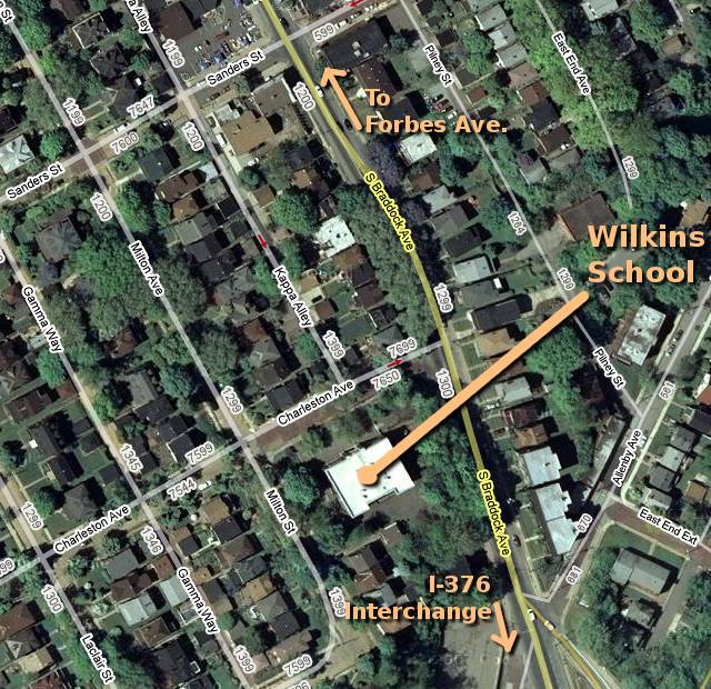
From the Parkway East (I-376), take the Edgewood/Swissvale exit onto Braddock Avenue going north. Go about three blocks, then turn left onto Sanders Street at the beer distributor. Take a left at the first stop sign onto Milton Street, and the Wilkins School is on the corner of Milton and Charleston one block ahead. There is on-street parking only, so locate a suitable space nearby and walk to the school.
From Oakland/Squirrel Hill, take Forbes Avenue east through Frick Park. Turn right onto Braddock Avenue for about 1/2 mile. Pass a Sunoco station on your left, then a block later turn right onto Sanders Street at the beer distributor. Take a left at the first stop sign onto Milton Street, and the Wilkins School is on the corner of Milton and Charleston one block ahead. There is on-street parking only, so locate a suitable space nearby and walk to the school.
Bus Info[edit]
The Port Authority's 61B bus stops nearby on Saturdays. You will get off at Charleston and Braddock. Then, you will walk up the hill 1/2 a block.
